Google Maps has added a new feature which will estimate how much you’ll spend on fuel when making a journey.
If you ask for directions on Google Maps (for example Birmingham to London), towards the bottom of the window you’ll see an estimated fuel cost:

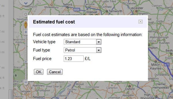
Clicking on the link then allows you to alter the type of car you drive (compact, standard or high consumption) type of fuel (petrol or diesel), and the price per litre, to give you a more accurate figure.

There’s no indication of where the data is coming from. The default petrol price of £1.23 per litre is already looking a bit of a bargain (so it’s at least a few weeks out of date), and there’s also no further details on what constitutes a standard or high consumption car, but perhaps over time Google can add in more detailed info based on car makes/models and their average fuel consumption.
Whilst it’s not a major feature it’s good to see this information presented alongside the journey directions – the directions themselves are usually very good, and together with Street View, it’s usually the only tool I need to use to plan a journey.
The next step will be to work out how this can save you money; perhaps suggesting an alternative cheaper route, or a different mode of transport. For example, would it be cheaper to get the train?
That is a pretty cool feature! I need to try it!
Thanks for posting!